Self-guided audio tour in Portland
Start Free on iPhone
Start free on iPhone to unlock this self-guided walking tour in Portland. Hear all the stories that make it amazing, walk at your own pace, and begin whenever you want.
Your Private Tour Guide
Portland, affectionately known as 'Bridgetown,' is a city defined by its relationship with the Willamette River. This self-guided walking route offers an immersive exploration of the city's architectural identity, connecting the vibrant West Side with the industrial-chic East Bank. As you navigate this loop, you will encounter the heavy-duty engineering of the early 20th century standing in stark contrast to the sleek, sustainable designs of the modern era. The walk highlights how Portland reclaimed its waterfront from industrial decay and highways, transforming it into a communal backyard filled with greenery and public art. The journey begins on the Hawthorne Bridge, a sentinel of steel that has served the city since 1910. From there, the route follows the curves of the Willamette through Governor Tom McCall Waterfront Park. This area is a testament to urban renewal, once a roaring freeway and now a peaceful stretch of lawn and cherry trees. You'll witness the interactive rhythm of the Salmon Street Springs and the neo-classical elegance of the Burnside Bridge, which offers some of the most photographed views of the 'Portland Oregon' sign. Crossing over to the Eastbank Esplanade, the atmosphere shifts. The path here floats on the river, providing a unique perspective of the skyline reflecting off the water. The walk concludes with a visit to the Oregon Museum of Science and Industry (OMSI) and a stroll across the Tilikum Crossing. This final bridge is a marvel of contemporary engineering—the first major bridge in the United States dedicated entirely to transit, cyclists, and pedestrians, with no cars allowed. Whether you are interested in the mechanics of vertical-lift bridges or simply want to find the best viewpoints for photography, this walking route provides a comprehensive look at the spirit of the Pacific Northwest. Experience the blend of nature and industry at your own pace, enjoying the crisp river air and the iconic silhouettes of Portland's most famous spans.
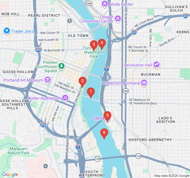
Numbers indicate the order of stops on the tour.
Begin your exploration at the Hawthorne Bridge, a true icon of Portland’s skyline. Completed in 1910, it is the oldest vertical-lift bridge still in operation in the United States. Notice the intricate lattice of steel and the massive counterweights that allow the central span to rise for passing ships. It was designed by the firm Waddell & Harrington, pioneers of the vertical-lift style. This bridge is more than just an engineering feat; it is one of the busiest bicycle crossings in the nation, reflecting Portland’s deep-seated cycling culture. As you walk across, you can feel the vibrations of the city moving around you and enjoy the first of many views of the Willamette River.
Moving north along the waterfront, you arrive at Salmon Street Springs. This fountain is a favorite gathering spot for locals, especially during the warm summer months. It features 185 water jets controlled by an underground computer system that changes the spray patterns based on the time of day and season. The fountain serves as a gateway to Tom McCall Waterfront Park. It was dedicated in 1988 and represents the city's commitment to public spaces that are both artistic and interactive. Take a moment to watch the 'misers,' 'oscillators,' and 'big guys'—the different types of jets—create their choreographed aquatic dance against the backdrop of the river.
This lush 30-acre park wasn't always a peaceful retreat. Until the 1970s, this land was occupied by Harbor Way, a multi-lane freeway that cut the city off from its river. Thanks to the vision of Governor Tom McCall, the highway was removed, and the park was created, sparking a revolution in urban planning. As you walk through, you'll pass memorials and expansive lawns that host many of Portland's major festivals. In the spring, the northern end of the park is famous for its 100 Akebono cherry trees, which create a canopy of pink blossoms. It is a premier example of how a city can reclaim its natural beauty from industrial infrastructure.
The Burnside Bridge, built in 1926, is an elegant bascule-style bridge—meaning it opens like a set of jaws. Designed with Neo-classical and Italian Renaissance elements, the towers on the bridge house the machinery used to lift the heavy spans. This bridge serves as a major artery connecting the east and west sides of the city. From the pedestrian walkway, look north to see the famous 'White Stag' sign, an iconic piece of Portland neon. The bridge is also unique because it sits atop the geographic center of the city’s street numbering system, dividing North and South Portland. It offers a spectacular vantage point for viewing the other bridges to the north, including the Steel and Broadway bridges.
After crossing the Burnside Bridge and heading south along the Eastbank Esplanade, you reach the Oregon Museum of Science and Industry, or OMSI. This area was once the heart of Portland’s industrial district, and the museum itself is housed in a former power plant. While the museum is a hub for interactive learning, the exterior is equally fascinating. You can spot the USS Blueback, a decommissioned Navy submarine moored in the river, which was featured in the film 'The Hunt for Red October.' The surrounding plaza offers a great place to rest and observe the river traffic, from tugboats to dragon boat racers, highlighting Portland’s maritime heritage.
Conclude your walk at the Tilikum Crossing, the 'Bridge of the People.' Opened in 2015, this is a bridge like no other in the country; it carries light rail, buses, streetcars, cyclists, and pedestrians, but absolutely no private cars. The name 'Tilikum' comes from the Chinook Wawa language, meaning 'people,' 'tribe,' or 'family.' The bridge is a stunning example of modern cable-stayed design, with sleek white pylons and vibrating cables. At night, the bridge is illuminated by 176 LED lights that change color based on the Willamette River’s speed, depth, and temperature. It is a fitting symbol of Portland’s future—focused on sustainability, public transit, and connection.
Start Free on iPhone
Explore “Bridges and the Willamette Waterfront” with your very own Private Tour Guide with Zigway. Start free on iPhone, skip the large group and the fixed routes, and hear the city come alive as you go.
Your Private Tour Guide
Don't miss the good stuff
Explore Freely
 Challenging
Portland, United States
Explore Portland's volcanic history and lush gardens on this self-guided route from the urban core to the summit of Mt. Tabor.
 Easy
EasyPortland, United States
Explore Portland's literary soul on this self-guided walk through legendary bookstores, historic libraries, and iconic architectural landmarks.
 Easy
EasyPortland, United States
Explore Portland's eerie history and hidden underground legends on this self-guided audio walk through the haunted streets of Old Town.
 Moderate
Portland, United States
Discover Portland's botanical soul on this self-guided walk through Washington Park’s world-famous rose and Japanese gardens.
 Moderate
Gothenburg, Sweden
Discover Gothenburg’s maritime soul on this self-guided walk from the historic Central Station to the scenic riverfront at Stenpiren.
 Moderate
Nairobi, Kenya
Discover Nairobi's lush side on this self-guided walk through botanical gardens, historic memorials, and vibrant local markets.
 Moderate
Vienna, Austria
Follow the footsteps of Mozart and Strauss through Vienna’s historic center on this self-guided walk through the city's rich musical history.
 Moderate
Vienna, Austria
Discover the noir world of The Third Man and Cold War Vienna on this atmospheric self-guided audio walk through the historic Innere Stadt.
 Easy
EasyNashville, United States
Explore the 'Athens of the South' on this self-guided walk through Centennial Park, featuring the world's only full-scale Parthenon replica.
 Easy
EasyNashville, United States
Explore Nashville's academic heart and Art Deco gems on this self-guided walk through historic Hillsboro Village.
 Easy
EasyNashville, United States
Explore the heart of Nashville's music industry. Discover iconic studios and the history of the legendary Nashville Sound at your own pace.
 Easy
EasyNashville, United States
Explore Nashville's oldest neighborhood! Discover Victorian architecture, Civil War history, and world-class craft beer on this self-guided walk.
